Hiking in San Diego: Scenic Trails You Can't Miss
Take a Walk Around San Diego’s Most Beautiful Landscapes
The best hiking in San Diego can be found just minutes from the city’s bustling downtown and further afield, in the wider county, near historic gold rush towns like Julian. Many of the mountain trails here cater to seasoned hikers who own robust boots and a set of poles. If you’re after a gentler walk, try the coastal paths where the elevations are minimal and there are plenty of rest stops along the way.
Our top picks list below will guide you through the best hikes in the region, from epic El Cajon Mountain with its 3,675-ft (1,120-meter) elevation to more easygoing trails.
1. Bayside Trail at Cabrillo National Monument
One of Southern California’s most dreamy day hikes

Good for: Couples, Families, Photo
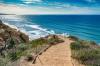
A 2.5-mile (4-km) round-trip, Bayside Trail at Cabrillo National Monument delivers spectacular vistas of San Diego Bay and the wider Pacific Ocean. Take in the vast azure waters peppered with tiny yachts and views of downtown, the Tijuana sandstone cliffs, and Coronado Island. The trailhead can be found near the Old Point Loma Lighthouse, a historic maritime attraction that dates to 1855.
This gravel and dirt path wends its way along the photogenic coastline and takes approximately 1 to 2 hours to complete. There are benches along the way that offer quality respite. Keep an eye out for the abundance of marine mammals that call this stretch home, including dolphins, seals, and sea lions.
Location: Bayside Trail, Cabrillo National Monument, San Diego, CA 92106, USA
Open: Daily from 9 am to 4 pm
Phone: +1 619-523-4285

Bayside Trail at Cabrillo National Monument
2. El Cajon Mountain
The jewel of the Cuyamaca Mountains
Good for: Adventure, Photo
An epic trail that takes up to 7 hours to complete, El Cajon Mountain looms over eastern San Diego and delivers astounding views of the surrounding terrain. Situated in the El Capitan County Preserve, this hike has long been considered one of the most difficult in the city due to its steep ascents that are covered with rocks.
The payoff is worth it, however. There are opportunities to spot majestic golden eagles and enjoy vistas of Iron Mountain, Los Pinos, and Mount Woodson beyond. At the summit, you can take a selfie at the turquoise sign, which shows you’ve reached an elevation of 3,675 ft (1,120 meters), before taking in the panoramic backdrop of Hot Springs Mountain.
Location: El Captain County Reserve, 13775 Blue Sky Rnch Rd, Lakeside, CA 92040, USA
Open: September–July: daily from 8 am to sunset. August: closed
Phone: +1 619-561-0580
El Cajon Mountain
3. Chollas Lake Park trail
A family-friendly beauty spot by a glimmering body of water
Good for: Families, Photo
Set in San Diego’s suburban Chollas View neighborhood, Chollas Lake Park trail is an easygoing trail that loops around a reservoir, leading to a children’s playground at Gloria’s Mesa. Taking approximately an hour to walk, this idyllic route is lined with trees, including eucalyptus, Peruvian peppers, and bright yellow cottonwoods. It’s also home to an abundance of birds like great-tailed grackles and graceful snowy egrets.
A 15-minute drive east of the city, Chollas Lake also offers free fishing clinics for kids under 15 years of age and archery lessons for those over eight. There are plenty of free tables for an al fresco picnic, and shelters can be hired for an affordable fee.
Location: 6350 College Grove Dr, San Diego, CA 92115, USA
Open: Daily from 6.30 am until 30 minutes before sunset
Phone: +1 619-527-7683
Chollas Lake Park trail
4. Cowles Mountain
The city’s highest elevation
Good for: Adventure, Photo
A prominent peak in the scenic San Carlos neighborhood, Cowles Mountain woos hikers with its 1,593-ft (486-meter) summit, which is the highest point in San Diego. Found inside Mission Trails Regional Park, the route to the top takes about 2 hours to complete and offers exhilarating views of downtown, as well as Mexico and Orange County.
To avoid the masses, set off in either the early morning or later in the afternoon, when eager hikers aren’t cluttering the trail. This is a totally unshaded pathway, so be sure to wear a hat and bring plenty of water for your adventure. Parking can be found on the road, just past Big Rock Park.
Location: Mission Trails Regional Park, 1 Father Junipero Serra Trail, San Diego, CA 92119, USA
Phone: +1 619-668-3281
Cowles Mountain
5. Three Sisters Falls
Nestled in a secret canyon in Cleveland National Forest
Good for: Adventure, Photo
You’ll find Three Sisters Falls about 30 minutes outside of Julian, a tiny historic town in San Diego County. When it’s flowing, this three-tier beauty is one of California’s most memorable natural attractions thanks to a thunderous cascade of Boulder Creek water that crashes down its rugged rockface.
This 4.2-mile (6.6-km) out-and-back hike ascends to 1,000 ft (305 meters), and you should allocate between 3 and 4 hours to complete the trip, wearing sturdy hiking boots and equipped with poles. Depending on rainfall levels, you might even find a freshwater pool where you can take a dip in hot weather. Parking can be found at the trailhead entrance off Boulder Creek Road.
Location: Cleveland National Forest, Three Sisters Falls Trail, Descanso, CA 91916, USA
Open: Monday–Friday from 8 am to noon and from 12.30 pm to 4.30 pm (closed on Saturdays and Sundays)
Phone: +1 858-673-6180
Three Sisters Falls
6. Mount Woodson (Potato Chip Rock)
An epic Instagram spot
Good for: Adventure, Photo, Unusual
One of California’s most photographed landmarks, Potato Chip Rock on majestic Mount Woodson can be found at a sky-high elevation of 2,130 ft (650 meters). The trailhead is 30 minutes north of San Diego in Lake Poway Park, which boasts cinematic views of the undulating hills as well as plenty of wooden picnic tables.
This 7.5-mile (12-km) hike is not for novices, with significant altitude gain and lack of shade, making it one of the area’s more challenging routes. The Potato Chip Rock summit showcases an eye-popping sheer ledge that juts out over the San Diego countryside. It’s a popular spot for photos, but caution is needed.
Location: Ramona, CA 92065, USA
Open: Daily from 6 am to 5 pm
Phone: +1 858-668-4772
Mount Woodson (Potato Chip Rock)
7. Iron Mountain Trail
The second highest peak in Poway
Good for: Photo, Couples, Adventure
Iron Mountain Trail never fails to enchant with its unobstructed views of northern San Diego County, the distant Pacific Ocean, and Catalina Island. The start of the trailhead looks like something out of Yellowstone, the hit US TV show, with its rustic cast-iron sign that frames a backdrop of breathtaking mountains.
It takes 3 hours to hike this 5.6-mile (9-km) route, which is considered moderate to challenging due to its 1,100-ft (335-meter) elevation gain. At the top, you can enjoy a picnic lunch at one of the tables before taking in sensational vistas from a range of viewfinders that cast their gaze over Cuyamaca Peak and downtown San Diego.
Location: Iron Mountain Trailhead, 14847-14909 CA-67, Poway, CA 92064, USA
Iron Mountain Trail
8. Volcan Mountain Trail
Incredible cinematic landscapes
Good for: Photo, Adventure
Volcan Mountain Trail is located inside the Volcan Mountain Wilderness Preserve, a 2,900-acre (1,174-hectare) expanse that’s littered with paths that lead to jaw-dropping outlooks. The former site of a 19th-century gold rush, Volcan’s trailhead is marked by a James Hubbell gateway sculpture, which is hand-carved from cedar and features depictions of buffalo, owls, eagles, and wolves.
You’ll ascend Volcan Mountain up an old unpaved road, which is surrounded by rolling Californian countryside that looks like something out of an oil painting. After you glimpse Cuyamaca Peak, veer off along the Five Oaks Trail, a serpentine slope that wends its way to the summit. From here, the views of Banner Canyon and the Laguna Mountains are truly extraordinary.
Location: Volcan Mountain Trailhead, 1107 Farmer Rd, Julian, CA 92036, USA
Open: Daily from 8 am to 6 pm
Phone: +1 760-765-4098
Volcan Mountain Trail
9. Guy Fleming Trail
A gentle seaside jaunt in the sunshine
Good for: Families, Photo
Part of the Torrey Pines State Natural Reserve, Guy Fleming Trail is a short 0.65-mile (1-km) loop that boasts springtime wildflowers, Mojave yuccas, and an easygoing elevation. On clear days, cast your eyes across the Pacific Ocean to see squadrons of flying pelicans or look to the water for pods of dolphins and whales. The path looks particularly beautiful at sunset.
Along the way, you’ll encounter some rather fabulous rock formations that wouldn’t look out of place in South Dakota’s Badlands, as well as vistas of San Clemente, La Jolla Cove, and Santa Catalina Island. Park your car in the dirt turnout just below the trailhead, or secure free street parking outside the park entrance.
Location: Torrey Pines Natural Reserve, 12600 N Torrey Pines Rd, La Jolla, CA 92037, USA
Open: Daily from 7.15 am to sunset
Phone: +1 858-755-2063
Guy Fleming Trail
10. Stonewall Peak Trail
For postcard-worthy panoramas
Good for: Adventure, Photo, Couples
Beginning at the Paso Picacho Campground in Cuyamaca Rancho State Park, Stonewall Peak Trail is a moderately difficult climb featuring long stretches of dusty track, interspersed with rocky obstacles. You’ll take in striking views of Cuyamaca Peak and its glittery lake, before ascending a flight of sheer rock stairs to Stonewall Peak’s amazing summit.
The visuals from up high are simply superb, with unobstructed views of the landscape made possible by a set of handy safety rails. The way back down is not for the faint-hearted, so be sure you want to reach the top before you begin your ascent. Nature enthusiasts will enjoy the variety of flora that lines the trail, including chaparral shrubs and incense cedar.
Location: Stonewall Peak Trail, Julian, CA 92036, USA
Open: Daily from 9 am to 8 pm
Phone: +1 760-765-0755
Stonewall Peak Trail
This article includes opinions of the Go Guides editorial team. Hotels.com compensates authors for their writing appearing on this site; such compensation may include travel and other costs.